With the maturity and research of drone technology and spectral sensor technology, the application of UAV remote sensing in various industries is rapidly advancing. As far as the application of forestry industry is concerned, UAV remote sensing has greatly reduced the inconvenience of transportation, high cost and hard work in traditional production research activities because of its flexibility, low cost of use, simple operation, rapid response and high spatial and temporal resolution. Shortcomings such as enterprise and revisiting cycles have made forestry production research jump from traditional small-scale, point-by-point sampling to large-scale, high-throughput, multi-dimensional comprehensive research. It is of great significance to promote the construction and development of modern intelligent forestry and precision forestry.
In late May, the EcoDrone UAS-8 multi-unit UAV multi-spectral remote sensing system introduced by Northeast Forestry University and the EcoDrone UAS-4 portable UAV multi-spectral remote sensing system introduced by Liaoning Academy of Forestry were respectively located on the campus of Northeast Forestry University. And the Liaoning Academy of Forestry Baishizizi Nature Reserve was successfully delivered. Yi Ketai Spectral Imaging and UAV Remote Sensing Technology Research Center was invited to carry out training and operation of forest resource management protection in Baishizizi Protected Area.
This is the first time that EcoDrone UAV remote sensing technology has been applied to modern intelligent forestry and precision forestry research in Northeast China, and will contribute to the protection of forest resources management in the region. 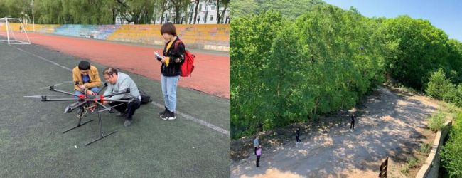
EcoDrone UAS-8 (left), EcoDrone UAS-4 (right) on-site training The EcoDrone UAV multi-spectral remote sensing system combines high-definition RGB imaging with multi-spectral imaging. It can simultaneously acquire RGB images, 5-channel multi-spectral images and other remote sensing data in one operation, providing accurate first-hand information for forestry research. . In this training operation, a total of 10,000 multi-spectral image data were obtained from the protected area station and the forest area. And generate a variety of thematic data such as DOM, NDVI, NDRE, DVI, RVI, etc., for the protection of forest resources management, precious tree species protection, biodiversity survey, wildlife habitat research, tree species identification, habitat assessment, vegetation assessment and other applications Strong data support. 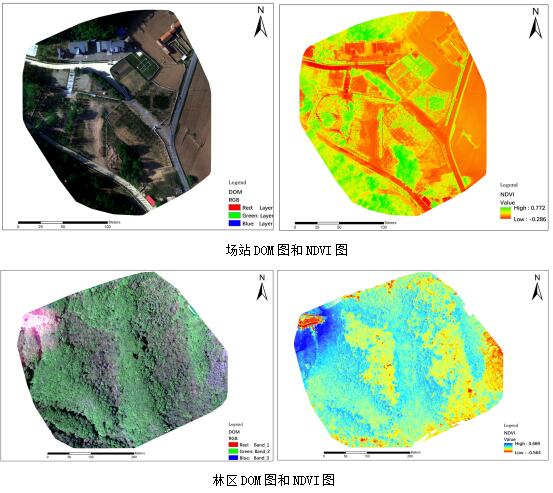 Comparing the color DOM and the vegetation coverage index NDVI, it can be found that there are two regions with low vegetation in the middle of the study area, and the vegetation coverage is low, and the surface can be seen faintly in the middle of the tree. And the shrub area is purple-red, and its NDVI value is generally low. According to the NDVI calculation formula (NDVI=(NIR-R)/(NIR+R)), it can be inferred that the shrub has strong reflection on the red band, and is close to Infrared band reflection is not as good as green tree vegetation. This can focus on the pigment composition of the shrub canopy and further analyze its physiological and ecological behavior.
In addition to the thematic data such as the spectral measurement index, the three-dimensional point cloud data of the study area can be extracted, and the three-dimensional information such as the canopy diameter, canopy circumference, tree height, and tree spacing of the forest can be directly measured, and the forest height is measured and forested. It has unique advantages in the acquisition of vertical structure information. As shown in the figure below, the measured tree height is 11.4m and the canopy diameter is 8m. 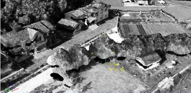
Yi Ketai Ecological Technology Co., Ltd. provides you with comprehensive solutions for spectral imaging:
Laboratory Spectral Imaging Technology Scheme Field Spectral Imaging Technology Scheme UAV Spectral Remote Sensing Scheme
In late May, the EcoDrone UAS-8 multi-unit UAV multi-spectral remote sensing system introduced by Northeast Forestry University and the EcoDrone UAS-4 portable UAV multi-spectral remote sensing system introduced by Liaoning Academy of Forestry were respectively located on the campus of Northeast Forestry University. And the Liaoning Academy of Forestry Baishizizi Nature Reserve was successfully delivered. Yi Ketai Spectral Imaging and UAV Remote Sensing Technology Research Center was invited to carry out training and operation of forest resource management protection in Baishizizi Protected Area.
This is the first time that EcoDrone UAV remote sensing technology has been applied to modern intelligent forestry and precision forestry research in Northeast China, and will contribute to the protection of forest resources management in the region.
EcoDrone UAS-8 (left), EcoDrone UAS-4 (right) on-site training
In addition to the thematic data such as the spectral measurement index, the three-dimensional point cloud data of the study area can be extracted, and the three-dimensional information such as the canopy diameter, canopy circumference, tree height, and tree spacing of the forest can be directly measured, and the forest height is measured and forested. It has unique advantages in the acquisition of vertical structure information. As shown in the figure below, the measured tree height is 11.4m and the canopy diameter is 8m.
Yi Ketai Ecological Technology Co., Ltd. provides you with comprehensive solutions for spectral imaging:
Laboratory Spectral Imaging Technology Scheme Field Spectral Imaging Technology Scheme UAV Spectral Remote Sensing Scheme
We're Professional Supplier Extract Powder manufacturers and suppliers in China specialized in providing high-quality products at low price. We warmly welcome you to buy or wholesale bulk Supplier Extract Powder for sale here from our factory. For a free sample, contact us now.
Supplier Extract Powder,Supplier Extract ,Supplier Powder Manufacturer in China
Shaanxi Kang New Pharmaceutical co., Ltd. , https://www.apipepdites.com